When Peter Minuit arrived on the Delaware River in March 1638 and founded the New Sweden colony, the first fortification he established was Fort Christina on the Minquas Kill. Presumably he selected the location based on the existing trade routes with the Native Americans. According to Acrelius, writing over a century later, another argument for choosing the west bank for a “fortification” was “because of the Dutch,” as they had already settled on the east bank, i.e. at Fort Nassau. Fort Christina was located at about two miles from the Delaware River, which led Amandus Johnson to suggest it was Minuit’s intention to avoid a direct confrontation with the Dutch, at least for the time being. It was a good location, as it had a good landing and was surrounded by marshland except on the north-eastern side, where a small strip of dry land provided access. Fort Christina was set up as a standard European-style fort: a square with four points. Three of the points were furnished with guns. The fort was built with palisades and earth. By autumn 1638 the fort was ready. It was solemnly named Christina by firing a salute.
After Minuit’s demise in the Caribbean, Peter Hollander Ridder was eventually appointed as his successor. Arriving in New Sweden in early 1640, he found Fort Christina in poor condition, with the walls falling down in places, proving again the difficulties involved in maintaining earthwork defences in North America. Ridder ordered repairs to the breaks in the walls and also mended the existing ramparts, but as he required permission from Sweden for this, it is unlikely that any further work was done. Within Fort Christina, Ridder had three new houses built after the two old houses had been moved to the east side of the fort. In 1644, Fort Christina was commanded by Johan Papegoja, who had three soldiers at his disposal, as well as a trumpeter, a constable, and a marshal-provost, but presumably could also draw upon others employed by the New Sweden Company if the need arose.
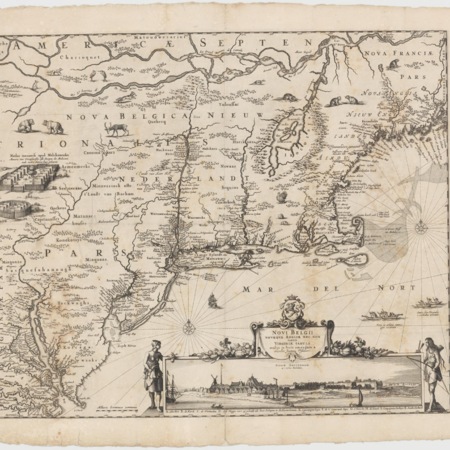
A map made by Per Mårtensson Lindeström (not currently included in the AMH) gives an indication of what Fort Christina looked like at this point in time. Lindeström was a Swedish engineer, who had attended the University of Uppsala, specializing in mathematics and fortifications. After a stay of three years in New Sweden, he returned to Europe and in later life prepared his manuscript entitled “Geographia Americae eller Indiae Occidentalis beskrijffningh,” which was not published until the twentieth century. In New Sweden, Lindeström was commissioned to survey the fields near Fort Christina and divide them into plots. It must have been at this time that he produced a map that included Fort Christina. It shows how close the fort was to the creek. Risingh had great plans for Fort Christina and its surroundings. In June 1655 he reported that he expected additional buildings to be constructed when more colonists arrived. He planned to have these built “in the form of a city, where it seems best to place the staple town, since a port can be made and the place can be fortified against attack.” Risingh may have dwelt secure against attacks by the Natives, but Fort Christina surrendered quickly when the Dutch arrived in force in September 1655. Director General Stuyvesant received instructions not to maintain Fort Christina, but to keep only three or four soldiers there to ensure it remained in Dutch hands. Fort Casimir was to be the main West India Company stronghold on the Delaware
This changed when the Amsterdam directors granted Fort Casimir and the surrounding area to the city of Amsterdam as the New Amstel patroonship. Fort Christina, now renamed Fort Altena (although the old name was still used at times), became the main fort of the West India Company. The Amsterdam directors provisionally ordered Stuyvesant to occupy it with eight to ten soldiers, with the aim to protect the Company’s Swedish subjects and to instill fear in potential enemies, both Native and European. In March 1660 the danger of an attack by the English in Maryland necessitated some repairs to the fort. Willem Beeckman, who had been appointed vice-director at the South River in 1658, asked Stuyvesant whether the batteries should be repaired with sods or beams. A month later he reported that they were “busy fitting the fortress with gabions and shall cut the decayed points down obliquely.” It is worth reminding that Beeckman had been in charge of making gabions in New Amsterdam four years earlier. It is likely that further attempts to reinforce Fort Altena were made in 1664. Fort Christina/Fort Altena is presumed to be located in what is now Fort Christina State Park on E. 7th Street in Wilmington, Delaware. The site is a National Historic Landmark and features the Fort Christina Monument. However, recent archaeological probing suggests that the park is located on filled-in wetlands rather than on the actual site of Fort Christina. The existence of any remains needs to be ascertained.